Qhapaq Ñan, one road one empire.
Google Earth
Google Earth software needed.
El-Ángel
Laguna Mojanda
Quito
Cuenca
Cajamarca
Cusco
Lac Titicaca
Désert d’Atacama
Salar d’Uyuni
Canyons de Tupiza
A mythical route forgotten by man
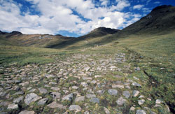
Imagine stone paving up to 20 meters wide, dressed steps climbing heights of over 4500m, walkways over water and suspension bridges spawning raging rivers. Envision single runners, chasquis, carrying messages on knotted strings called quipus at lightening speed in relay from one end of the empire to the other or imagine thousands of troops marching in line, their footsteps thundering in approach. Or visualize the Inca himself, seated on a litter lined with feathers and plated with gold and silver, being carried by more than 80 lords, the road before him being swept and adorned with petals…
 The vertebrae to a circulatory system of roads that covers more than 30,000 km in a geographical region savagely beautiful but unforgiving to link both the Pacific Coast and the Amazon Basin, the Qhapaq Ñan is a mythical route to rival that of the Romans in the west or that of the Silk Road of the ancient east.
This royal road joined the cities of Quito, Ecuador to the north and Santiago, Chile in the south permitting the Inca to control his Empire and to send troops as needed from the capital, Cusco. Along the route were warehouses, relay stations, llama corrals, living quarters and military posts spaced intermittently of varying sizes and grandeur.
 Much of this route stood at an altitude between 3500 and 5000 meters and with sections reaching 20 meters in width, it connected populated areas, administrative centers, agricultural and mining zones as well as ceremonial centers.
The Qhapaq Ñan unified this immense and heterogeneous empire through a well organized political system of power. Today, it has the potential to strengthen the bond between the different peoples of the Andes, who share a longstanding common culture.


